
Kit Harris visits a long-forgotten field.
To delve into the annals of cricket history is to be confronted with an abundance of statistics – and a surfeit of firsts. We know, for example, that the first match between two county elevens was played between Kent and Surrey at Dartford Brent on June 29, 1709, for a prize of £50. The ground was just north of the Pilgrims’ Way, and though it was subsequently built over, there is still cricket at Hesketh Park, a few steps to the east.
We know that the oldest surviving ground to host a county versus county game is Richmond Green, where Surrey hosted Middlesex in June 1730. We know of seven other such grounds from the four decades that followed – at Dulwich Common, Sevenoaks, Chislehurst, Merrow, Ripley, Finsbury and Hambledon.
We know, too, that a ground named Laleham Burway hosted the first first-class game between two counties – Surrey and Kent, on June 21, 1773. Hambledon’s Broadhalfpenny Down had already held the first first-class match, between Hampshire and England the previous year (see page 120 of Wisden 2022), and is still regarded as the cradle of first-class cricket. But Laleham Burway has just as many tales to tell.
It was at here that Thomas White, playing for Chertsey – the home club – against Hambledon in September 1771, strode out with a bat as wide as the wicket. Several visiting players wrote a letter of protest to the committee of the London Cricket Club who had written the first Laws of Cricket, three decades earlier. For their part, the Chertsey men were unimpressed by the growing custom of the Hambledon batters to use their pads as a second line of defence. In 1774, the Laws were revised, stipulating a maximum bat width, and introducing the lbw dismissal.
And it was here that a middle stump was added, for a game between Chertsey and Coulsdon in September 1776. Its necessity had become clear the year before, when Kent and Hambledon staged a five-a-side contest at the Honourable Artillery Club in Finsbury: the match was at a crucial juncture when Edward “Lumpy” Stevens three times bowled John Small through the gate, without hitting stump or bail. Stevens was a renowned cricketer – so important, in fact, that he was often allowed to choose where the wickets should be pitched for a game. It was hardly surprising that, after his experience at Finsbury, he insisted upon the addition of a third stump.
Chertsey Cricket Club still exists, though cricket ceased at Laleham Burway in 1784, or soon afterwards. Today, the location of the ground is something of a mystery. Laleham Burway was a large water meadow, about a mile long from north to south, on the west bank of the River Thames. The estate of Laleham, which owned Laleham Burway, sat on the east bank. A foot ferry manor and meadow, but the locals would drive their cattle across each morning to graze.
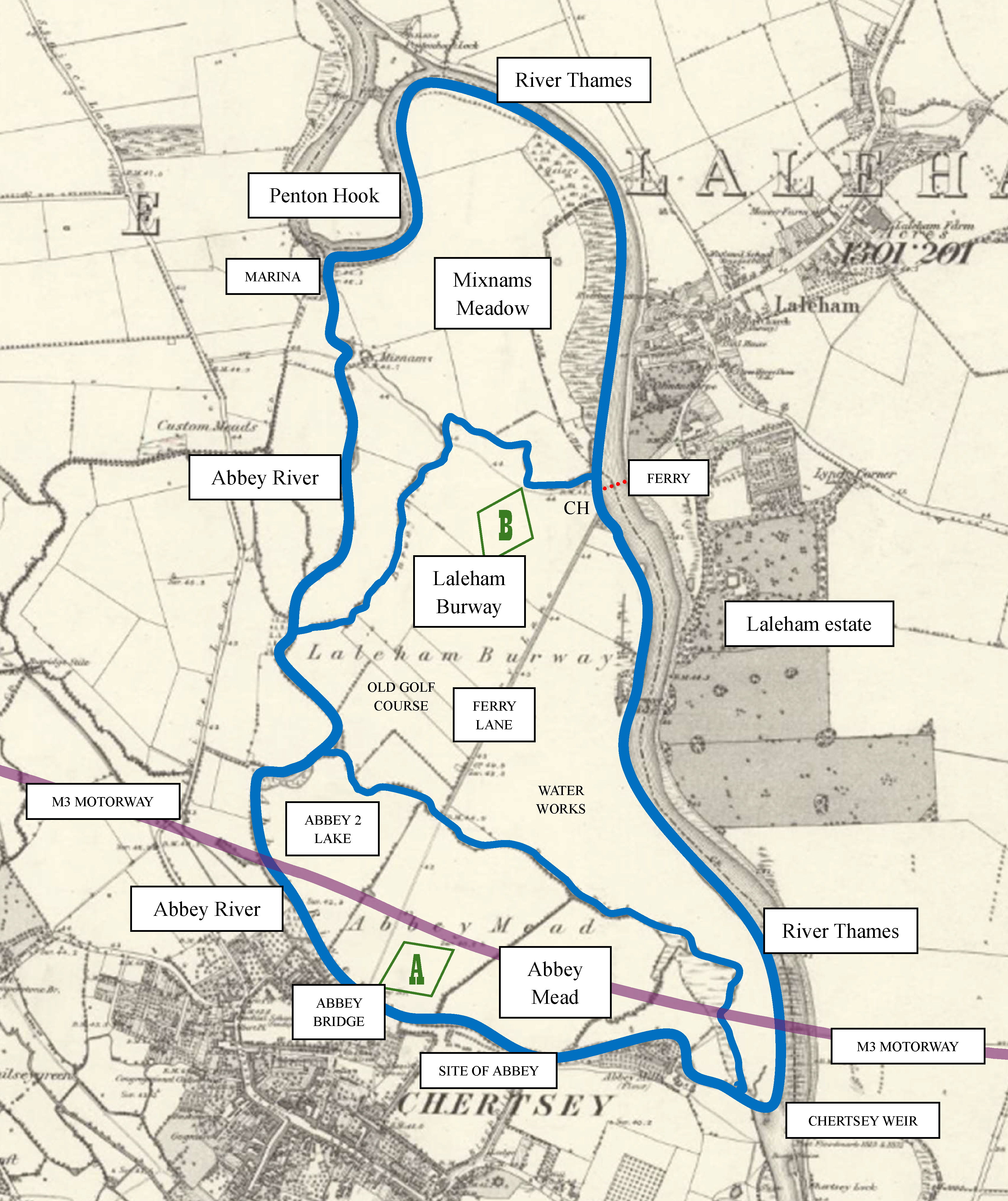
Laleham Burway is part of a larger island, formed by the Abbey River, a distributary of the Thames which flows south from Penton Hook Marina to the fringes of Chertsey, then turns east, passing the site of Chertsey Abbey, before rejoining the Thames at Chertsey Weir.
The island is in three parts, separated by creeks. At the north end is Mixnams Meadow, now partially occupied by the mobile homes of Penton Park and the waterfront properties of Laleham Reach.
A winding creek – marked on modern maps as the Burway – meanders to the Abbey River from the derelict clubhouse of a now defunct golf club. The creek separates Mixnams Meadow from Laleham Burway; the ferry from the estate arrived on the bank by the clubhouse. Running south from the landing stage is an arrow-straight path called Ferry Lane, which bisects Laleham Burway. All the land to the east of the path is owned by the Chertsey Water Works; to the west is the old golf course.
At the south end of the island is Abbey Mead, bisected from north to south by Ferry Lane. Bridging the M3 motorway and the Abbey River, Ferry Lane reaches Chertsey at the site of the former Abbey.
Twenty venues are known to have staged games between counties before the advent of first-class cricket. Aside from the nine surviving grounds mentioned above, another eight locations are identifiable.
In Surrey, Carshalton Park is still there, though the likely location of the cricket ground is now under houses between the High Street and Ruskin Road. Moulsey Hurst was in the centre of the old racecourse at Hurst Park in West Molesey. Kennington Common became Kennington Park, which has a modern artificial pitch to the east of the former ground, near The Oval.
In Kent, the ground at Coxheath is thought to have been by the Star Inn, replaced by the houses of McAlpine Crescent.
In Sussex, games were played at the Dripping Pan in Lewes, now the home of the local football club.
In Middlesex, Lambs Conduit Field ground in London is now, more or less, under Argyle Square Gardens. Chelsea Common was built on in the first few years of the 19th century.
In Essex, the field by The Crown Inn at Billericay, where the team played their first county game, against Kent in June 1761, is now a railway cutting.
Three locations, all on hills, have not been pinpointed. One is somewhere on Bury Hill, north of Arundel, where Sussex hosted Surrey in August 1745; another is on Long Down, west of Eartham, where the teams met again in September 1752. And in July 1768, Middlesex hosted Surrey in a field on Stamford Hill, off the old Ermine Street turnpike between Stoke Newington and Tottenham; it was the only recorded game there.
A fourth unknown location, Laleham Burway – the 21st ground to host two counties – is by far the most significant. The wickets were not pitched on a whim, as they must have been on the hills and downs. It was a major venue for decades: Chertsey played here from 1736, Surrey from 1773, and England from 1777 (and possibly earlier). In the 1770s, a stand was erected, providing the “best accommodation”, according to a report in the Surrey Advertiser. It was arguably the most prominent ground outside London – and it had to be easily accessible to spectators as well as participants. But where was it?
Location A – The mead
There were only two points of access to Laleham Burway. From Chertsey, it could be reached by Ferry Lane, over Abbey Bridge. The 1869 map depicts the bridge as leading to Abbey Mead, but cadastral maps held in the Chertsey Museum show that, in 1772, Abbey Mead was part of Laleham Burway; it does not appear as separately enclosed until 1814. White and Stevens could have locked horns in a meadow opposite the ruins of the Abbey – marked A on the map. The trouble with this theory is that the ground would have been very wet here. The Abbey River routinely flooded the Mead: the later map shows several drainage ditches were added when the fields were enclosed.
In fact, the whole island has a history of flooding. A photograph taken by the Environment Agency during the Thames floods of 2014, taken from above the Penton Hook Marina, looking south-east towards Chertsey Bridge (by the weir), shows all of Abbey Mead inundated, either side of the motorway embankment. The Water Works are partially flooded, as is the southern portion of the golf course. The one dry spot is around a diamond-shaped enclosure in the bottom left-hand corner of the photograph.
Location B – The enclosure
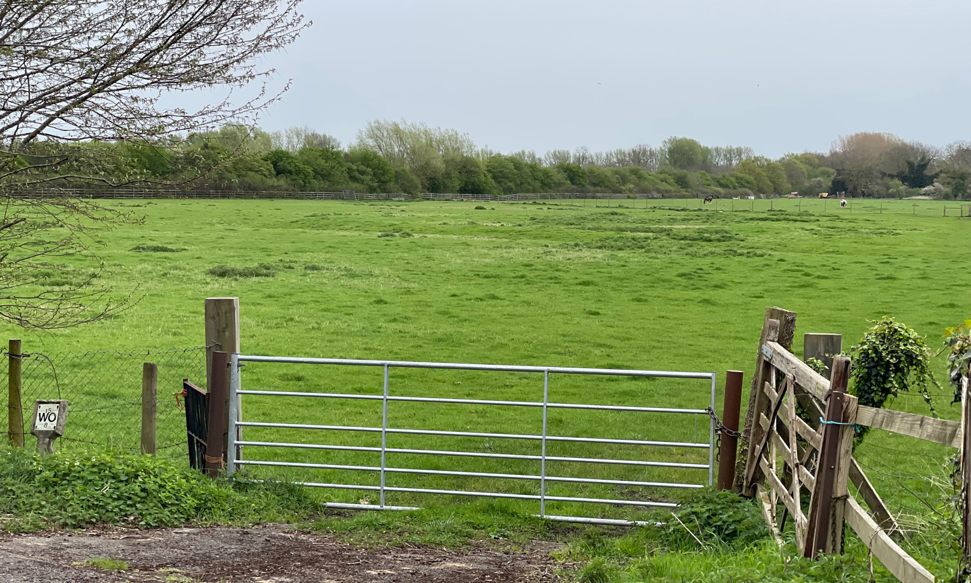
The enclosure – marked B on the map – is thought by Historic England to be the site of a temporary Roman marching camp. It would have been flat-floored, and slightly elevated above the fields around it. Laleham Burway remained common land until 1813, when the third Lord Lucan purchased it, and divided it into fields for tenanted farmers. The enclosure has been through a good deal since. The golf club became tenants in 1903, and landscaped extensively; the Luftwaffe dropped phosphorous bombs there in the Second World War. The club bought the land outright in 1996, but fell behind on their mortgage repayments, and sold it to Thorney Farm Developments Ltd in 2008. When the golfers departed in 2017, the land was rented to cattle farmers.
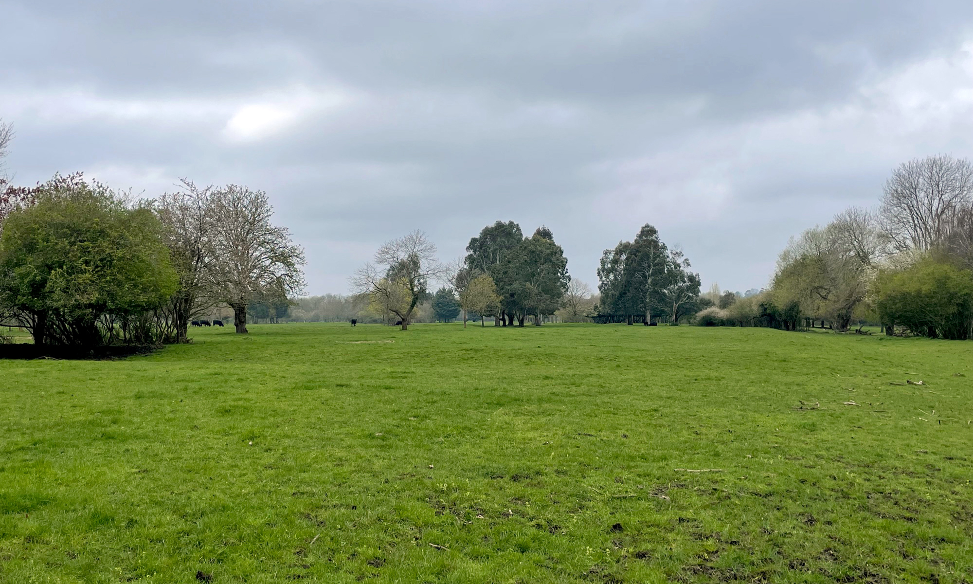
It is not quite possible to reach the enclosure now, on account of the cows, but a public right of way, leading from the abandoned clubhouse to the Penton Park mobile homes, comes within about 20 metres of the northern corner. It is indeed flatter and higher than the rest of the field – hydrological maps show it is the part of Laleham Burway likeliest to remain dry during severe floods – and is only 200 metres from the landing stage of the Laleham ferry.
This, surely, is the prime candidate for the location of the ground. It is hard to imagine a wooden stand here, among the cattle, but in the spring air, looking south across verdant pasture, one can almost hear the lowing of men in their prime – and the bickering of White and Stevens.
Kit Harris is Assistant Editor of Wisden Cricketers’ Almanack.

You must be logged in to post a comment.